How to Draw Russia (map) with this how-to video and step by step drawing instructions. Easy map drawing tutorial for beginners and everyofne.

Please see Russia drawing tutorial in the video below
Russia is the largest country in the world, spanning 11 time zones and sharing land borders with 14 countries. It is the ninth most populous country in the world and the most populous country in Europe. Russia is a highly urbanized country consisting of 16 population centers with more than one million inhabitants. Its capital as well as largest city is Moscow. Saint Petersburg is Russia’s second largest city and its cultural capital.
You can refer to Russia simple step by step drawing guide below
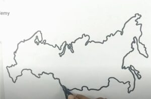
Step 1. First draw the border and northern coastline

In the north of Russia, there is a long coastline bordering the Arctic and in the northwest it borders the countries of Latvia, Lithuania, and Estonia.
Step 2. Continue drawing the western border

The western border is quite close to the entire territory of Russia but is adjacent to many countries such as Azerbaijan, Belarus, Finland, Georgia, Kazakhstan, Mongolia, Norway, Poland and Ukraine.
Step 3. Move on to drawing the eastern part

The east is basically adjacent to the long coastline and adjacent to the border with North Korea.
Step 4. Draw the southern border
Similar to the northern territory, the southern part of Russia has a long territorial border adjacent to large countries such as China, Kazakstan, and Mongolia.
Step 5. Draw the islands of Russia

Next, draw the islands of Russia. Russia has many large and small islands, especially in the arctic region.
Step 6. Draw the states of Russia
Next draw the states of Russia. All federal administrative units of Russia are grouped in 8 federal regions of Russia.
Step 7. Color the map
Use different colors to color the federal districts.